I built TerraSol to help solar developers decide which sites were worth pursuing.
Start with a developer’s problem.
A solar developer told me that only about one in five prospective properties worked out. Initial site evaluations could take a month of gathering information and visiting the property.
I built TerraSol to do the vast majority of that initial assessment in about five minutes. It became software for developers, and one adopted it as their primary site assessment tool across the mid-Atlantic.
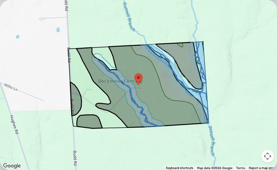
The assessment flags protected wetlands, a stream crossing the parcel, and a setback from a nearby stream. Those constraints affect how much land can be used and how a project can be laid out.
The gray polygons screen for slope using mapped soil units; they are not measurements of every point on the ground. Blue lines and bands mark streams and screening buffers. Areas are preliminary estimates.
Put the pieces together.
Land
Parcel boundaries, wetlands, streams, canopy, slope, and soils inform the estimate of usable acreage.
Grid
Energy modeling estimates substation capacity and distance to three-phase lines. Grid access can limit what the land can support.
Economics
The application connects project size and production estimates to cash flows, lease terms, revenue sharing, and developer returns.
Zoning
AI analyzes local zoning requirements and organizes the approval paths and construction standards a developer needs to investigate.
AI zoning research
What would it take to get permission?
The same location can have different approval paths depending on the project. TerraSol compares likely districts and separates requirements by solar category.
Excerpt / AI-generated assessmentAR
Agricultural Reserve
Selected output for solar collection systems requiring site-plan approval, up to 2 MW.
Setback
“All structures must be located at least 50 feet from any property line.”
Height
“All structures must be 20 feet in height or less.”
Utility connection
“Written authorization from the local utility company is required for systems connected to the utility grid.”
Still to resolve
The report flags uncertainty about which Agricultural Reserve rules also apply to the separately described Agricultural district.
More of the analysis +
The sample reviews Rural, Agricultural Reserve, Rural Cluster, and Agricultural district candidates. Its output includes:
Approval paths by system size, review bodies, and required documents.
Setbacks, height, lot coverage, screening, fencing, glare, and landscaping standards.
Utility authorization, acreage calculations, and decommissioning requirements.
In the Agricultural Reserve discussion, it distinguishes on-site generation up to 200% of baseline energy use, the site-plan category up to 2 MW, and a conditional-use path for larger facilities.
This is a sample of the application’s AI output, not a confirmed parcel-specific zoning determination. District and project applicability still require review.
I built the application end to end.
That included the geospatial analysis, proprietary energy modeling, financial models, and AI zoning research. I checked the infrastructure estimates against public data in states that publish it.
I later brought in a CTO, which let me step away from development and spend more time with customers.
TerraSol is still maintained and used by developer partners.